HPAI Spillover
Zoonosis Risk
How do natural sources of highly pathogenic avian influenza (HPAI) at the wildlife–agriculture interface influence spillover risk in California’s Central Valley?
During late 2021, the HPAI outbreak commenced in North America and circulated among 165 wild bird species with a broader host range than the 2014-2015 outbreak. Waterfowl have consistently tested positive for the influenza in addition to new hosts: previously unaffected wild birds, wild and domestic mammals, and humans. The HPAI H5N1 virus has demonstrated some mammalian mutations and been found in over 1,600 poultry operations in every U.S. state and Puerto Rico, almost 1,000 dairy farms in 17 states, and 70 humans. In the state of California, occupational exposure to dairy cows and poultry with suspected HPAI increases the individual risk of infection. The first human case of HPAI in the state was identified in September 2024 by monitoring workers on farms with infected cows. From September 30–December 24, 2024, 38 persons tested positive for HPAI A (H5N1); of those individuals, 37 worked on a dairy farm and one was a child with an unknown exposure, marking the first pediatric case in the U.S.
On December 18, 2024, California Governor Gavin Newsom declared a State of Emergency for H5N1. The state recruited local, state, and federal technical and operational expertise to facilitate a robust response to the virus including the U.S. Food and Drug Administration, U.S. Department of Agriculture, Centers for Disease Control, and California Department of Public Health. With each animal that is infected by avian influenza, there is another chance for the virus to evolve into a pathogen fit for human-to-human transmission. Creating early warning systems built on a One Health framework–integrating human, animal, and environmental health–are a wise investment to support state biosecurity.
Since 2006, the USDA National Wildlife Disease Program (NWDP) in partnership with the California Department of Food and Agriculture has established a surveillance framework sampling wild birds for HPAI and other pathogens that may impact domestic poultry, wild bird species, and humans. NWDP wildlife disease biologists serve as sentinels in the program’s Surveillance and Emergency Response System (SERS) and have collected over 500,000 samples to date. Existing disease surveillance frameworks like SERS can be bolstered to account for environmental conditions, host behavior, and community dynamics, informing conservation strategies for timely interventions that safeguard human and animal health.
Central Valley
California’s Central Valley is bisected into two valleys: Sacramento Valley and San Joaquin Valley. Every year approximately 1 billion wild birds migrate through them on the Pacific Flyway. The flyway encompasses a system of wetlands ranging from Alaska and western Canada to the western U.S. and Mexico to Central America and South America. Wetlands, ecosystems that are transitional between the terrestrial and the aquatic, within the Central Valley provide wintering habitat for nearly 60 percent of migratory waterfowl (Garone, 2020).
HPAI Hosts
Wild birds in the Orders Anseriformes (ducks and geese) and Charadriiformes (shorebirds) are the primary hosts of avian influenza viruses, however they can also disseminate the virus to intermediate hosts. For a species to be considered a bridge host, it must: overlap in time and space with maintenance hosts, either replicate a given pathogen within the body or transport the pathogen on its body surface, and lack the capacity to persist a virus without first being infected by a maintenance host (Owen et al., 2021). Thus, assessing species use of habitat, contact rate, and behavior across spatial and temporal scales is necessary for a bridge host designation. A potential bridge host may spread the virus to poultry and cows by entering farms through building breaches and vents, open doors, or open-air environments, contaminating the feed and water.
Project Objective
The project will explore the county in Central Valley with the highest HPAI detection in wild birds which is Yolo County, nested within the smaller Sacramento Valley. Two sources of pathogen transmission will be studied in synanthropic wild birds: maintenance hosts and bridge hosts. The data will encompass features ranging from vegetation to a crucial agent affecting virus infectivity (surface water temperature). The temporal scope will be isolated to the wintering period for maintenance hosts (mid-October through January). Given characteristics associated with host presence and high infectivity in addition to host daily range, a risk score will be calculated for raster cells based on either similarity or proximity to hosts, resulting in a composite risk raster for the county indicating seasonal spillover risk from a prominent waterfowl habitat.
Data Description
U.S. Geological Survey Daily Values Service maintains current and historical data from time-series equipment at monitoring water sites. CACHE C OUTFLOW FROM SETTLING BASIN NR WOODLAND CA site was selected to obtain daily water temperature (°C) values provided in 30 minute intervals.
GBIF Occurrence data was retrived from the Global Biodiversity Information Facility Occurrence Store and scoped to the wintering period and habitat. There are 105 occurrences across seven species.
Yolo County and Yolo Bypass Wildlife Area boundaries were retrieved from the California State Geoportal. California County Boundaries is a GIS layer hosted by the California Department of Forestry and Fire Protection. CDFW Public Access Lands dataset offers locations which are publicly accessible lands owned or operated by the California Department of Fish and Wildlife.
Data Citation
California State Geoportal. (2024). California County Boundaries [Data set]. https://gis.data.ca.gov/datasets/CALFIRE-Forestry::california-county-boundaries
California State Geoportal. (2025). CDFW Public Access Lands [Data set]. https://gis.data.ca.gov/datasets/CDFW::cdfw-public-access-lands-ds3077
Global Biodiversity Information Facility. (2025). GBIF Occurrence Download: House Sparrow [Data set]. https://doi.org/10.15468/dl.m5wyf6
Global Biodiversity Information Facility. (2025). GBIF Occurrence Download: Killdeer [Data set]. https://doi.org/10.15468/dl.ju8c56
Global Biodiversity Information Facility. (2025). GBIF Occurrence Download: Mallard [Data set]. https://doi.org/10.15468/dl.zu2sa4
Global Biodiversity Information Facility. (2025). GBIF Occurrence Download: Red-winged Blackbird [Data set]. https://doi.org/10.15468/dl.nmukt7
Global Biodiversity Information Facility. (2025). GBIF Occurrence Download: Rock Pigeon [Data set]. https://doi.org/10.15468/dl.ac99st
Global Biodiversity Information Facility. (2025). GBIF Occurrence Download: Savannah Sparrow [Data set]. https://doi.org/10.15468/dl.hekvd4
Global Biodiversity Information Facility. (2025). GBIF Occurrence Download: Snow Goose [Data set]. https://doi.org/10.15468/dl.kdaytc
USGS Daily Values Service. (2025). CACHE C OUTFLOW FROM SETTLING BASIN NR WOODLAND CA [Data set]. https://waterdata.usgs.gov/monitoring-location/11452900
Methods
The most recent wintering period for migratory waterfowl (10/20/2024-01/31/2025) was selected for the USGS Daily Values Service, querying for surface water temperature from a main habitat inlet. Daily mean, minimum, and maxium temperature values were calculated and displayed concurrently with holoviews.
The species occurrences data was accessed by the Python client for the GBIF API and subset for the temporal scope, species of interest, and habitat coordinates. Each occurrences CSV file was ingested using the pandas library. Species occurrence was normalized by month for the sampling effort and reduced to four species: Agelaius phoeniceus, Anser caerulescens, Charadrius vociferus, and Passerculus sandwichensis. Both daily and monthly observations for the four species were plotted over the winter period.
Analysis
Imports
import warnings
warnings.filterwarnings('ignore')

import sys
import os
import time
import pathlib
import zipfile
from getpass import getpass
from glob import glob

import pandas as pd
import geopandas as gpd
import cartopy.crs as ccrs
import holoviews as hv
import hvplot.pandas
hvplot.extension('bokeh')
import pygbif.occurrences as occ
# Access GBIF

reset_credentials = False
# GBIF needs a username, password, and email
credentials = dict(
    GBIF_USER=(input, ''),
    GBIF_PWD=(getpass, ''),
    GBIF_EMAIL=(input, ''),
)

for env_variable, (prompt_func, prompt_text) in credentials.items():
    # Delete credential from environment if requested
    if reset_credentials and (env_variable in os.environ):
        os.environ.pop(env_variable)
    # Ask for credential and save to environment
    if not env_variable in os.environ:
        os.environ[env_variable] = prompt_func(prompt_text)
Set Paths
# Plots
plots_dir = os.path.join(
    # Home directory
    pathlib.Path.home(),
    'Projects',
    # Project directory
    'zoonosis-risk',
    'plots'
)

# Project data directory
data_dir = os.path.join(
    # Home directory
    pathlib.Path.home(),
    'Projects',
    # Project directory
    'zoonosis-risk',
    'data'
)

# CA boundaries
boundary_dir = os.path.join(
    # Home directory
    pathlib.Path.home(),
    'Projects',
    # Project directory
    'zoonosis-risk',
    'boundary_data'
)

# Boundaries
county_dir = os.path.join(boundary_dir, 'ca-county-boundaries')
pub_land_dir = os.path.join(boundary_dir, 'ca-public-access-lands')
# Species
gbif_snow_goose_dir = os.path.join(data_dir, 'gbif', 'snow-goose')
gbif_mallard_dir = os.path.join(data_dir, 'gbif', 'mallard')
gbif_red_winged_blackbird_dir = os.path.join(data_dir, 'gbif',
                                             'red-winged-blackbird')
gbif_savannah_sparrow_dir = os.path.join(data_dir, 'gbif', 'savannah-sparrow')
gbif_house_sparrow_dir = os.path.join(data_dir, 'gbif', 'house-sparrow')
gbif_killdeer_dir = os.path.join(data_dir, 'gbif', 'killdeer')
gbif_rock_pigeon_dir = os.path.join(data_dir, 'gbif', 'rock-pigeon')

os.makedirs(plots_dir, exist_ok=True)
os.makedirs(data_dir, exist_ok=True)

os.makedirs(county_dir, exist_ok=True)
os.makedirs(pub_land_dir, exist_ok=True)
os.makedirs(gbif_snow_goose_dir, exist_ok=True)
os.makedirs(gbif_mallard_dir, exist_ok=True)
os.makedirs(gbif_red_winged_blackbird_dir, exist_ok=True)
os.makedirs(gbif_savannah_sparrow_dir, exist_ok=True)
os.makedirs(gbif_house_sparrow_dir, exist_ok=True)
os.makedirs(gbif_killdeer_dir, exist_ok=True)
os.makedirs(gbif_rock_pigeon_dir, exist_ok=True)
Load Utility Functions
def normalize_occurrences(df):
    """
    Normalize occurrence data for given species.

    Args:
    occ_df (pandas.DataFrame): DataFrame of species occurrence.

    Returns:
    norm_occ_df (pandas.DataFrame): DataFrame of normalized species occurrence.
    """

    occ_df = (
        df
        # For each month
        .groupby(['host_name', 'month'])
        # count the number of occurrences
        .agg(occurrences=('host_name', 'count'))
    )

    # Drop rare observations (possible misidentification)
    occ_df = occ_df[occ_df["occurrences"] > 1]

    # Take the mean by month
    mean_occurrences_by_month = (
        occ_df
        .groupby(['month'])
        .mean()
    )

    occ_df['norm_occurrences'] = (
        occ_df
        / mean_occurrences_by_month
    )

    return occ_df
def load_gbif(gbif_csv):
    """
    Load occurrence data from GBIF CSV.

    Args:
    gbif_csv (str): A path to downloaded species CSV.

    Returns:
    (pandas.DataFrame): A species occurrence DataFrame.
    """
    return pd.read_csv(
        gbif_csv,
        delimiter='\t',
        index_col='gbifID',
        on_bad_lines='skip',
        usecols=['gbifID', 'order', 'species', 'month', 'day', 'year',
                 'decimalLatitude', 'decimalLongitude']
    )
def download_gbif(species, gbif_credentials, species_dict,
                  period, site_bounds):
    """
    Download occurrence data for given species.

    Args:
    species (str): Input host species name.
    gbif_credentials (dict): GBIF API credentials.
    species_dict (dict): Host species GBIF metadata.
    period (str): Temporal range of observations.
    site_bounds (list): Site boundary coordinates.

    Returns:
    gbif_path (str): A path to downloaded species CSV.
    """

    gbif_dir = species_dict[species]['DATA PATH']
    species_key = species_dict[species]['GBIF SPECIES']
    species_download_key = species_dict[species]['GBIF DOWNLOAD']
    site_latitude = f'{site_bounds[1]},{site_bounds[3]}'
    site_longitude = f'{site_bounds[0]},{site_bounds[2]}'

    # Only download once
    gbif_pattern = os.path.join(gbif_dir, '*.csv')
    if not glob(gbif_pattern):
        # Submit query to GBIF
        gbif_query = occ.download([
            f"speciesKey = {species_key}",
            f"eventDate = {period}",
            f"decimalLatitude = {site_latitude}",
            f"decimalLongitude = {site_longitude}",
            "hasCoordinate = TRUE",
        ],
        user=gbif_credentials['GBIF_USER'][1],
        pwd=gbif_credentials['GBIF_PWD'][1],
        email=gbif_credentials['GBIF_EMAIL'][1])

        # Only download once
        if not species_download_key in os.environ:
            os.environ[species_download_key] = gbif_query[0]

            # Wait for the download to build
            wait = occ.download_meta(
                    os.environ[species_download_key])['status']
            while not wait=='SUCCEEDED':
                wait = occ.download_meta(
                        os.environ[species_download_key])['status']
                time.sleep(5)

            # Download GBIF data
            download_info = occ.download_get(
                os.environ[species_download_key],
                path=gbif_dir)

            # Unzip GBIF data
            with zipfile.ZipFile(download_info['path']) as download_zip:
                download_zip.extractall(path=gbif_dir)

    # Find the extracted .csv file path
    gbif_path = glob(gbif_pattern)[0]

    return gbif_path
Sites
# Set up California County Boundaries - Yolo (2024) path
yolo_path = os.path.join(county_dir, 'ca_county.geojson')

# Load in the county data
yolo_county_gdf = gpd.read_file(yolo_path)

# Site plot
yolo_boundary_plt = (
    yolo_county_gdf
    .to_crs(ccrs.Mercator())
    .hvplot(
        title='Yolo County',
        line_color='#ffb403', fill_color=None,
        line_width=3,
        crs=ccrs.Mercator(), tiles='EsriImagery',
        frame_width=600, frame_height=650)
)
# Set up California Department of Fish and Wildlife (CDFW) Public Access Lands path
pub_land_path = os.path.join(pub_land_dir, 'ca_public_access_land.geojson')

# Load in the Yolo Bypass Wildlife Area data
yolo_bypass_gdf = gpd.read_file(pub_land_path)

# Nested habitat
(
    yolo_boundary_plt * yolo_bypass_plt
).opts(
    title='Yolo County and Bypass Wildlife Area',
    width=600, height=650
)
Yolo County spans 1,014 square miles with substantial water resources such as the Sacramento River, Putah Creek, and Cache Creek. Yolo Bypass Wildlife Area contains 16,000 acres with seasonal and year round ponds, grasslands, and riparian forest nested habitats. The area covers 0.025% of the greater county and is vital for the farmers, hunters, and wild birds in the Central Valley.
Surface Water Temperature (Habitat Inlet)
"""
USGS Daily Values Service
Station: Cache C Outflow From Settling Basin NR Woodland CA - 11452900
About: Inlet to Yolo Bypass Wildlife Area
Time period: 10-20-2024 to 01-31-2025
Metric: Temperature, water, degrees Celsius
"""

USGS_DAILY_URL = (
    'https://nwis.waterservices.usgs.gov/nwis/iv/?'
    'sites=11452900&agencyCd=USGS&'
    'startDT=2024-10-20T00:00:00.000-07:00&'
    'endDT=2025-01-30T23:59:59.999-08:00&'
    'parameterCd=00010&format=json'
)

usgs_daily_water = pd.read_json(USGS_DAILY_URL)
# Transform dates

usgs_daily_water_time_series = usgs_daily_water.iloc[1]
dwts_values = usgs_daily_water_time_series.value[0]['values'][0]['value']
dwts_df = pd.DataFrame(dwts_values)

dwts_df = dwts_df.assign(
    datetime_date=lambda x: pd.to_datetime(x['dateTime']))

dwts_df['date'] = dwts_df.datetime_date.apply(lambda x: pd.to_datetime(
                                                x.strftime('%Y-%m-%d')))
# Plot daily surface water temperatures

dwts_df_subset = dwts_df[['date', 'value']]
dwts_df_subset['water_temperature'] = dwts_df_subset[
                                        'value'].astype(float)
dwts_df_subset.drop('value', axis=1, inplace=True)

daily_water_temps = dwts_df_subset.groupby('date').agg(
    Minimum=('water_temperature', 'min'),
    Maximum=('water_temperature', 'max'),
    Average=('water_temperature', 'mean')
)

daily_water_temps.hvplot.line(
    label='Daily Surface Water Temperature (Yolo Bypass Wildlife Area Inlet)',
    xlabel='Date', ylabel='Temperature',
    height=500, width=900,
    legend='top_right', group_label='Temperature (°C)'
)
Duration of HPAI infectivity in water is associated with low water temperatures between 4-17 °C (Brown et al., 2009). At the daily average, from late October onward the virus would likely remain stable in the habitat. About 20 days later and thereafter the daily maximum and minimum temperatures would continue to be conducive to a higher infectivity rate than the preceding period.
Hosts
HOSTS = {
    'Snow Goose': {
        'DATA PATH': gbif_snow_goose_dir,
        'GBIF SPECIES': '2498167',
        'GBIF DOWNLOAD': 'GBIF_DOWNLOAD_KEY_2498167'
    },
    'Mallard': {
        'DATA PATH': gbif_mallard_dir,
        'GBIF SPECIES': '9761484',
        'GBIF DOWNLOAD': 'GBIF_DOWNLOAD_KEY_9761484'
    },
    'Red-winged Blackbird': {
        'DATA PATH': gbif_red_winged_blackbird_dir,
        'GBIF SPECIES': '9409198',
        'GBIF DOWNLOAD': 'GBIF_DOWNLOAD_KEY_9409198'
    },
    'Savannah Sparrow': {
        'DATA PATH': gbif_savannah_sparrow_dir,
        'GBIF SPECIES': '5231142',
        'GBIF DOWNLOAD': 'GBIF_DOWNLOAD_KEY_5231142'
    },
    'House Sparrow': {
        'DATA PATH': gbif_house_sparrow_dir,
        'GBIF SPECIES': '5231190',
        'GBIF DOWNLOAD': 'GBIF_DOWNLOAD_KEY_5231190'
    },
    'Killdeer': {
        'DATA PATH': gbif_killdeer_dir,
        'GBIF SPECIES': '2480320',
        'GBIF DOWNLOAD': 'GBIF_DOWNLOAD_KEY_2480320'
    },
    'Rock Pigeon': {
        'DATA PATH': gbif_rock_pigeon_dir,
        'GBIF SPECIES': '2495414',
        'GBIF DOWNLOAD': 'GBIF_DOWNLOAD_KEY_2495414'
    }
}
Snow Goose
gbif_snow_goose_csv = download_gbif('Snow Goose', credentials, HOSTS,
                             "2024-10-20,2025-01-31",
                             yolo_bypass_gdf.total_bounds)

gbif_snow_goose_df = load_gbif(gbif_snow_goose_csv)
Mallard
gbif_mallard_csv = download_gbif('Mallard', credentials, HOSTS,
                             "2024-10-20,2025-01-31",
                             yolo_bypass_gdf.total_bounds)

gbif_mallard_df = load_gbif(gbif_mallard_csv)
Red-winged Blackbird
gbif_red_winged_blackbird_csv = download_gbif(
                                        'Red-winged Blackbird',
                                        credentials, HOSTS,
                                        "2024-10-20,2025-01-31",
                                        yolo_bypass_gdf.total_bounds)

gbif_red_winged_blackbird_df = load_gbif(gbif_red_winged_blackbird_csv)
Savannah Sparrow
gbif_savannah_sparrow_csv = download_gbif(
                                        'Savannah Sparrow',
                                        credentials, HOSTS,
                                        "2024-10-20,2025-01-31",
                                        yolo_bypass_gdf.total_bounds)

gbif_savannah_sparrow_df = load_gbif(gbif_savannah_sparrow_csv)
House Sparrow
gbif_house_sparrow_csv = download_gbif(
                                        'House Sparrow',
                                        credentials, HOSTS,
                                        "2024-10-20,2025-01-31",
                                        yolo_bypass_gdf.total_bounds)

gbif_house_sparrow_df = load_gbif(gbif_house_sparrow_csv)
Killdeer
gbif_killdeer_csv = download_gbif(
                                        'Killdeer',
                                        credentials, HOSTS,
                                        "2024-10-20,2025-01-31",
                                        yolo_bypass_gdf.total_bounds)

gbif_killdeer_df = load_gbif(gbif_killdeer_csv)
Rock Pigeon
gbif_rock_pigeon_csv = download_gbif(
                                        'Rock Pigeon',
                                        credentials, HOSTS,
                                        "2024-10-20,2025-01-31",
                                        yolo_bypass_gdf.total_bounds)

gbif_rock_pigeon_df = load_gbif(gbif_rock_pigeon_csv)
Normalize by time for the sampling effort
# Concatenate all species occurrences
host_species_df = pd.concat([gbif_snow_goose_df, gbif_mallard_df,
                             gbif_red_winged_blackbird_df,
                             gbif_savannah_sparrow_df,
                             gbif_house_sparrow_df, gbif_killdeer_df,
                             gbif_rock_pigeon_df]).reset_index()

# Include host names
HOST_NAMES = {
    'Anser caerulescens': 'Snow Goose',
    'Agelaius phoeniceus': 'Red-winged Blackbird',
    'Anas platyrhynchos': 'Mallard',
    'Charadrius vociferus': 'Killdeer',
    'Columba livia': 'Rock Pigeon',
    'Passer domesticus': 'House Sparrow',
    'Passerculus sandwichensis': 'Savannah Sparrow'
}

host_species_df['host_name'] = host_species_df['species'].apply(
                                    lambda species: HOST_NAMES[species])
host_species_norm_occ_df = normalize_occurrences(host_species_df)
host_species_norm_occ_df = host_species_norm_occ_df.reset_index()
host_species_norm_occ_df.hvplot.violin(
    label='Host Species Occurrence (Wintering Period 2024-2025)',
    y='occurrences', by='host_name', c='host_name',
    xlabel='Species', ylabel='Occurrences',
    ylim=(-20, 50),
    cmap=['#ADE8F4', '#0096C7', '#74C365', '#478800'], legend='top_left',
    group_label='Species', width=800, height=800, padding=0.4)
The Savannah Sparrow followed by the Snow Goose exhibited the widest data distribution and highest probability of large observations (~10+) during the wintering period.
# Monthly Occurrences

MONTHS = {1: 'January', 10: 'October', 11: 'November', 12: 'December'}

host_species_norm_occ_df['month_name'] = (host_species_norm_occ_df
                                          ['month'].apply(
                                          lambda month: MONTHS[month]))

monthly_occ_df = host_species_norm_occ_df.sort_values(by='month')

all_host_occ = pd.merge(host_species_df, monthly_occ_df,
                        on=['host_name', 'month'], how='inner')
all_host_occ.rename(columns={'host_name': 'Host'}, inplace=True)
all_host_occ.hvplot.scatter(
    title="Yolo Bypass Daily Species Occurrence (Winter 2024-2025)",
    x='day', y='month_name', s='norm_occurrences',
    by='Host', legend='top_left',
    scale=10, xlabel='Day', ylabel='Month',
    height=600, width=700)
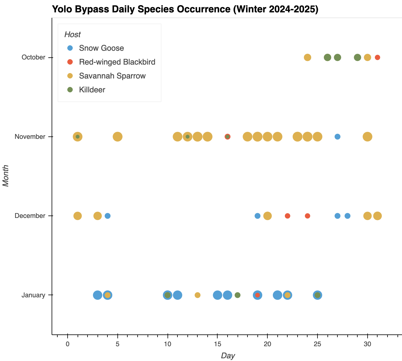
Snow Goose occurrence coincides with a greater accumulation of waterfowl at the end of the non-breeding season. Although there are fewer observations of Killdeer and Red-winged Blackbird, they remain throughout the period.
Discussion
Seasonal patterns of HPAI spillover risk will be complicated by changes in climate and loss of suitable overwintering habitat. The reduction of wetlands due to extended drought will relocate significant concentrations of waterfowl toward constructed refuges and flooded agricultural lands, resulting in the emergence of more frequent and larger outbreaks of avian disease. In the non-breeding season, changes in environmental conditions may support increased contact between wild birds and domestic birds in agricultural areas, generating opportunity for viral reassortment and subsequently, new host species (Morin et al., 2018). At present the Yolo Bypass Wildlife Area inlet offers favorable conditions for a high HPAI infectivity rate (Brown et al., 2009) from late November to February, comprising the majority of the migratory wintering period. Nonetheless, warming could lessen the duration of infectivity for cold-adapted pathogens both in breeding and non-breeding waters, leading transmission to be influenced more by co-occurrence with shedding waterfowl (Hill et al., 2016). The timing and patterns of migration as well as the availability of food resources will also adjust with warming and produce overwintering sites with greater densities of waterfowl, still vulnerable to substantial outbreaks.
Synanthropic species associated with agricultural environments in North America (Owen et al., 2021) and observed in Yolo Bypass Wildlife Area, encompassing species in the Orders Anseriformes (ducks and geese), Charadriiformes (shorebirds), Columbiformes (pigeons and doves), and Passeriformes (perching birds), were targeted for the county. After the data were normalized, the species observational extent was reduced to the following: Snow Goose, Savannah Sparrow (passerine), Red-winged Blackbird (passerine), and Killdeer (shorebird). In the Sacramento Valley and greater Central Valley, Northern Shovelers (ducks) have demonstrated the highest avian influenza prevalence and have been identified as a key species to target for future sampling (Bianchini et al., 2021). The anatomy of HPAI transmission requires a more expansive surveillance however that goes beyond maintenance hosts to involve bridge hosts. Sampling of peridomestic birds such as passerines has occurred in natural settings and areas of resident maintenance hosts, but there have been few instances of sampling in areas either regularly visited by waterfowl or adjacent to or on poultry and dairy farms (Shriner et al., 2016). The identification of bridge hosts within a given region requires simultaneously testing both on wetlands and nearby farms. The presence and use of agricultural operations by wild birds is not as well studied in the Americas as in other locations, and consequently a framework for HPAI transmission in such operations is narrow (Owen et al., 2021). Bridge hosts can amplify the speed and severity of infections; one study of wild birds on farms and wetlands (Caron et al., 2014) found that maintenance hosts and target populations were 20 times more likely to connect through bridge hosts than direct contact. Another study (Gaukler et al., 2012) surveyed the behavior of a synanthropic passerine species and noted that there is an additional risk posed by them: potential bridge hosts may frequent multiple farms rather than targeting just one for resources, thereby accelerating pathogen dispersal and the chances of a wider outbreak. More species-specific studies of likely bridge hosts and their use of farms are required for a stronger understanding of the spatial and temporal dynamics regarding between-host processes and HPAI transmission in California’s Central Valley. Evidenced by these findings, the project will concentrate future analysis and modeling on these elements: 1) Cultivating a deeper understanding of bridge host behavior in Yolo County and across the Central Valley; 2) Analyzing the impact of changes in vegetation on host foraging; 3) Incorporating climate projections for the county to inform the risk assessment and subsequent conservation planning; and 4) Developing monthly county risk rasters with focal species in the wintering season to better track HPAI transmission between the community of wild birds.
References
Bianchini, E. A., Bogiatto, R. J., Donatello, R. A., Casazza, M. L., Ackerman, J. T., De La Cruz, S. E. W., … Cline, T. D. (2021). Host correlates of avian influenza virus infection in wild waterfowl of the Sacramento Valley, California. Avian Diseases, 66(1), 20-28. https://doi.org/10.1637/aviandiseases-D-21-00071
Brown, J. D., Goekjian, G., Poulson, R., Valeika, S., & Stallknecht, D. E. (2009). Avian influenza virus in water: Infectivity is dependent on pH, salinity and temperature. Veterinary Microbiology, 136(1-2), 20-26. https://doi.org/10.1016/j.vetmic.2008.10.027
California Department of Food and Agriculture. (n.d.). Wildlife Services Program. https://www.cdfa.ca.gov/AHFSS/animal_health/Wildlife_Services.html
California Department of Public Health. (n.d.). Bird flu. https://www.cdph.ca.gov/Programs/CID/DCDC/Pages/Bird-Flu.aspx
California Water Science Center. (n.d.). California’s Central Valley. USGS. https://ca.water.usgs.gov/projects/central-valley/about-central-valley.html
Caron, A., Grosbois, V., Etter, E., Gaidet, N., & de Garine-Wichatitsky, M. (2014). Bridge hosts for avian influenza viruses at the wildlife/domestic interface: an eco-epidemiological framework implemented in southern Africa. Preventive Veterinary Medicine, 117(3-4), 590-600. https://doi.org/10.1016/j.prevetmed.2014.09.014
Chamberlain, S. (2024). pygbif (Version 0.6.4) [Computer software]. GitHub. https://github.com/gbif/pygbif/releases/tag/v0.6.4
Cornell Lab of Ornithology (n.d.). Yolo Bypass Wildlife Area. eBird. https://ebird.org/hotspot/L443535/bird-list
Executive Department State of California. (2024, December 18). Proclamation of a State of Emergency. Governor Gavin Newsom. https://www.gov.ca.gov/wp-content/uploads/2024/12/CORRECT-ATTESTED.pdf
Garone, P. (2020). The fall and rise of the wetlands of California’s great Central Valley. University of California Press.
Gaukler, S. M., Homan, J. H., Linz, G. M., & Bleier, W. J. (2012). Using radio-telemetry to assess the risk European Starlings pose in pathogen transmission among feedlots. Human–Wildlife Interactions, 6(1), 30-37. https://doi.org/10.26077/mtpq-ht61
Hill, N. J., Ma, E. J., Meixell, B. W., Lindberg, M. S., Boyce, W. M., & Runstadler, J. A. (2016). Transmission of influenza reflects seasonality of wild birds across the annual cycle. Ecology Letters, 19, 915–925. https://doi.org/10.1111/ele.12629
Jordahl, K., Van den Bossche, J., Fleischmann, M., Wasserman, J., McBride, J., Gerard, J., … Leblanc, F. (2024). geopandas/geopandas: v1.0.1 (Version 1.0.1) [Computer software]. Zenodo. https://doi.org/10.5281/zenodo.12625316
Met Office. (2024). Cartopy: a cartographic python library with a Matplotlib interface (Version 0.24.1) [Computer software]. Zenodo. https://doi.org/10.5281/zenodo.13905945
Morin, C. W.., Stoner-Duncan, B., Winker, K., Scotch, M., Hess, J. J., Meschke, J. S., … Rabinowitz, P. M. (2018). Avian influenza virus ecology and evolution through a climatic lens. Environment International, 119, 241-249. https://doi.org/10.1016/j.envint.2018.06.018
One Health Institute. (n.d.). What is One Health?. University of California Davis School of Veterinary Medicine. https://ohi.vetmed.ucdavis.edu/about/one-health
Owen, J. C., Hawley, D. M., & Huyvaert, K. P. (Eds.). (2021). Infectious disease ecology in wild birds. Oxford University Press.
Python Software Foundation. (2024). Python (Version 3.13.2) [Computer software]. https://docs.python.org/release/3.12.6
Sacramento Audubon Society. (n.d.). Pacific Flyway conservation. https://www.sacramentoaudubon.org/pacific-flyway-conservation
Shriner, S. A., Root, J. J., Lutman, M. W., Kloft, J. M., VanDalen, K. K., Sullivan, H. J., … DeLiberto, T. J. (2016). Surveillance for highly pathogenic H5 avian influenza virus in synanthropic wildlife associated with poultry farms during an acute outbreak. Scientific Reports, 6, 1-11. https://doi.org/10.1038/srep36237
Rudiger, P., Liquet, M., Signell, J., Hansen, S. H., Bednar, J. A., Madsen, M. S., … Hilton, T. W. (2024). holoviz/hvplot: Version 0.11.2 (Version 0.11.2) [Computer software]. Zenodo. https://doi.org/10.5281/zenodo.13851295
The pandas development team. (2024). pandas-dev/pandas: Pandas (Version 2.2.3) [Computer software]. Zenodo. https://doi.org/10.5281/zenodo.3509134
White, L. (2025, March 18). Winter 2025 update on highly pathogenic avian influenza H5. USGS. https://www.usgs.gov/media/files/nwhc-wildlife-health-bulletin-avian-influenza-update
Yolo County Resource Conservation District. (n.d.). Yolo Bypass Wildlife Area. https://yolorcd.org/what-we-do/yolo-bypass-wildlife-area
Zhu, S., Harriman, K., Liu, C., Kraushaar, V., Hoover, C., Shim, K., … California Department of Public Health H5 Laboratory Response Team (2025). Human cases of highly pathogenic avian influenza A(H5N1) — California, September–December 2024. MMWR and Morbidity and Mortality Weekly Report, 74, 127-133. http://dx.doi.org/10.15585/mmwr.mm7408a1